Basalt and Washington’s Coastline: Shaped by the Sea
CIC Museum Research Document (Created 12/8/2025) Creative Commons photograph.
Slow and Steady
Basalt is an extremely durable fine-grain igneous rock that forms from hot, low-silica magma rich in iron. Molten basalt is low viscosity, meaning it is thinner than other types of magma, allowing it to flow easily. Basaltic eruptions tend to be slower and less explosive, spreading out in wide sheets on land or forming rounded pillow basalts underwater. In contrast, explosive lava rich with silica (refined quartz, the main ingredient in glass), makes magma thicker and better at trapping gas, which results in violent volcanic eruptions.
Blankets of Water, Pillows of Rock
About 144 million years ago, the area now known as Grays Harbor looked much different from the sandy beaches and dunes we see today. Most of the region was submerged beneath a shallow inland sea that connected directly to the Pacific Ocean. Beneath the waves, molten basalt erupted onto the seafloor, where rapid cooling by cold ocean water caused the lava to form distinctive rounded shapes known as pillow basalts.
Pillow basalts form when basaltic magma erupts underwater and its outer surface chills quickly into a glassy crust while the interior remains molten and inflates the structure like a “pillow”. As lava continues to inflate into the cooled crust of basalt it eventually fractures, allowing more molten lava to emerge and form adjacent pillows. Many pillows developed elongated downward projections called keels where lava poured into surrounding chilled crust or adjacent pillows, which helps geologists to recognize underwater volcanic environments in ancient basalt formations.
In Grays Harbor, pillow basalts are uncommon and often subtle, but traces of these ancient underwater eruptions can still be found where older volcanic rocks are exposed along the coast. Small, weathered pillow structures can be found in bedrock outcrops near the headlands of Grayland and Westport, as well as along the northern edge of the Quinault coast, particularly in areas where waves have washed away younger sediments.
Eroding Forces and Changing Coastlines
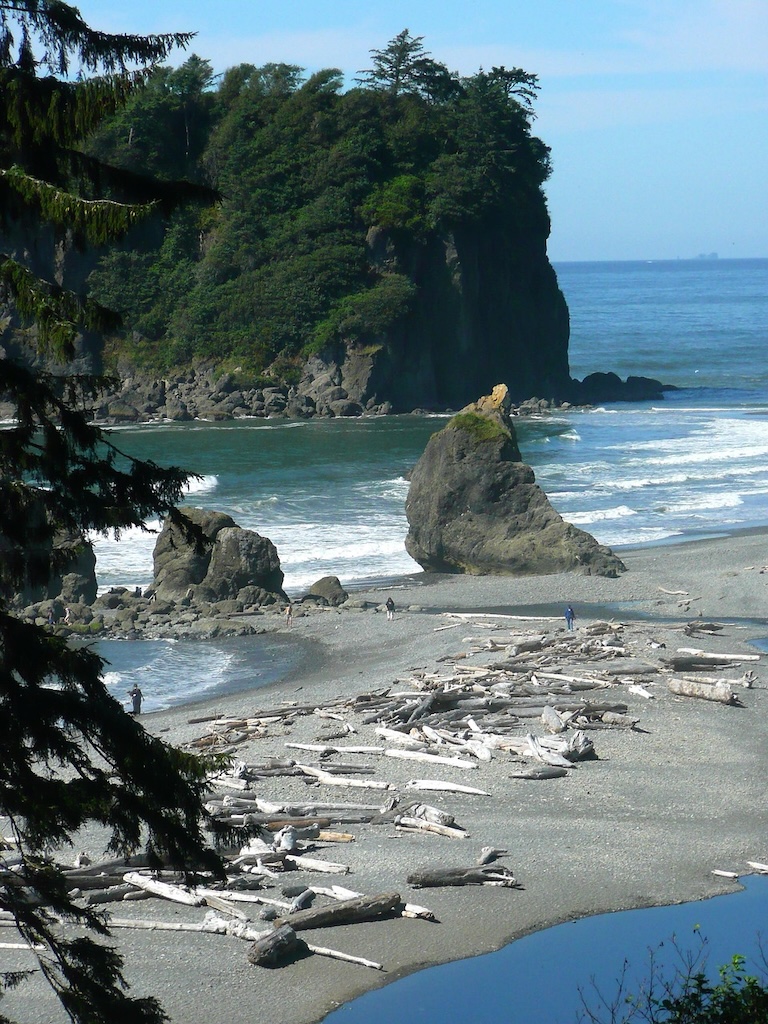
Compared to other shorelines in Washington, Grays Harbor shorelines contain relatively few basalt deposits. This scarcity is due to the coastline being primarily underlain by softer sedimentary rocks and younger deposits that are more susceptible to erosion. These materials wear away more quickly than resistant basalt, resulting in broader sandy beaches and a continually changing shoreline. Along the sandy shores of Grays Harbor, waves and currents readily move sand and other unconsolidated sediments, gradually reshaping the coast. These dynamic beaches shift in response to wind, tides, and storms—contrasting greatly against the slow changing basalt-rich headlands found elsewhere along Washington’s coast.
South of Taholah, rocky outcrops such as Point Grenville (also known by its Quinault name, Haynisisoos) rise from the ocean as resistant basalt and related rocks that have withstood the sculpting force of waves for millions of years. Wave action slowly carves features into these durable rocks, sometimes leaving behind arches, tunnels, and sea stacks where surrounding softer materials have eroded away over long periods of time.
Adapting to Changing Landscapes:
The Pacific coast of Washington is not a static place but a landscape in motion, shaped over millions of years by the interacting forces of geology and the sea. For thousands of years Indigenous communities have thrived along this dynamic coast and have long lived with change and continue to adapt. In recent years the impacts of climate change have caused storms to become stronger and sea levels to rise. In response to climate change coastal communities are forced to make a choice— find a solution to mitigate the damage or relocate. The Quinault Indian Nation’s village of Taholah, located where the Quinault River meets the Pacific Ocean, has experienced increasingly frequent flooding and storm impacts due to rising seas and storm surges, prompting a multi‑year effort to relocate homes and community infrastructure to higher ground. This move reflects both the immediate realities of coastal change and the deeper history of a people whose ancestors have known, used, and cared for these shores since time immemorial. The impermanence of these landscapes remind us that coastlines are continually reshaped by natural forces, from ancient underwater lava flows to modern storms and rising seas. These forces at work connect our coastline to millions of years of change, but is an enduring issue for established coastal communities.
Sources
- “Pillow Basalts (U.S. National Park Service).” National Parks Service, U.S. Department of the Interior, Apr. 2023, www.nps.gov/articles/000/pillow-basalts.htm.
- "McCarthy, T. & Rubidge, B. The Story of Earth and Life, Chapter 3, The first continent. 60-91, Apr 2009, Struik Publishers"
- Washington State Department of Natural Resources, Division of Geology and Earth Resources. Geology of the Grays River Quadrangle, Washington. Geological Report GM-4, Washington State Department of Natural Resources, www.dnr.wa.gov/Publications/ger_gm4_geol_graysriver_62k.pdf
- Rau, Weldon W. “Rock Formations and Their Geologic History.” Washington DNR: Geology of the Washington Coast between Point Grenville and the Hoh River (Part I), Washington Department of Natural Resources, Mar. 2006, www.npshistory.com/publications/geology/state/wa/1973-66/sec1-4.htm.
- “Washington 100.” Shi Shi Beach and Point of Arches, Washington Department of Natural Resources, Apr. 2019, wa100.dnr.wa.gov/olympic-peninsula/shi-shi-beach.
- Masquelier-Page, Alice. “For at Least a Decade Quinault Nation Has Tried to Escape the Rising Pacific. Time Is Running Out.” The Associated Press, 15 July 2024, www.ap.org/news-highlights/spotlights/2024/for-at-least-a-decade-quinault-nation-has-tried-to-escape-the-rising-pacific-time-is-running-out/